
The land surveying and mapping program in Nicholls geomatics has upgraded its research laboratory in Ellender Memorial Library. The geomatics program has existed on campus a little more than five years, and it is the only program in the state, Balaji Ramachandran, assistant professor of applied sciences, said.
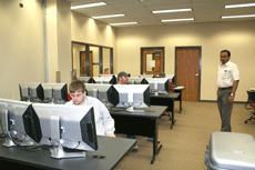
The lab, located on the first floor of the Ellender Memorial Library, is 1,400 square ft., and has the latest software in Geographic Information System (GIS).
The lab is for geomatics students’ instruction and research, Ramachandran said.
There are 25 workstations, including 34-inch dual monitors and industrial-sized processors costing $5,000, Ramachandran said.
An example of a Geographic Information System is an ecosystem model for Louisiana dealing with its the coastal erosion issues; baseline monitoring information can be collected to look at shifts over a period of time Ramachandran said.
To get the information into the database in the map format, we use satellites to collect data, and that would be considered remote sensing, Ramchandran said.
Remote sensing means sending something without touching it. A video photograph is a form of remote sensing, Ramachandran said.
“Beyond photographs, we have sensors for infrared so a person can look at the weather, radar and weather maps that someone sees in news,” Ramachandran said.
The geomatics program offers a four-year degree to those students completing the curriculum.
Although there have been only four graduates from the program, spring enrollment is up 42 students.
“There is a big demand for surveyors,” Ramachandran said.
The average age of surveyors in Louisiana is 54-years-old, Ramachandran said.
“They had to go to the high schools to recruit students and let them know there are opportunities right here at Nicholls,” Ramachandran said.
“Most of my graduates made somewhere between $42,000 and $45,000 per year,” Ramachandran said.
Jobs in this discipline are limitless: work in a sheriff’s office or in emergency response and homeland security are just two of the jobs offered in geomatics.
“My students are pretty much taken before they get out of school, all of them,” Ramachandran said.
The students are placed in internships, and they get connections there, too, Ramachandran said.
“Post Katrina and Rita, Louisiana needs a lot of surveyors and mappers both,” Ramachandran said.