

Nicholls’ geomatics program, the only one in the state, opened its Geospatial Technology Center, a state of the art computer lab in Ellender Memorial Library.The Geospatial Technology Center features 25 computer workstations, a high-definition projection system, four terabytes of server capacity, an unmanned aerial mapping vehicle, several GPS mapping units and a high-speed interconnection to the Louisiana Optical Network Initiative – a network connecting research universities throughout Louisiana and Mississippi.
“It’s a state of the art facility and we’re really proud to have it here at Nicholls,” said Balaji Ramachandran, assistant professor of geomatics.
The center serves as a workstation for geomatics students as well as professional land surveyors throughout the state. Ramachandran said the program and the center received strong support from the Louisiana Society of Professional Surveyors, an organization devoted to supporting the education and employment of young land surveyors.
Six senior projects, which Ramachandran said are of professional quality, have already been completed using the lab. Through the center’s access to the Global Positioning System, students will be able to monitor oyster beds for the local fishing industry or map out the state’s coastline, Ramachandran said.
“Working with real-world data gives our students real-world experience. We’re trying to provide solutions to local problems such as coastal erosion.”
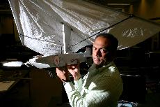
The center also has an unmanned aerial mapping vehicle that can be launched by hand which is similar to the drones used by the U.S. military in Iraq, Ramachandran said. The vehicle will offer aerial mapping like Google Maps, but the vehicle’s use would not be limited to certain times of day, allowing the center to get up to date information whenever they need it.
The center is in the final stages of approval from the FAA for flying the vehicle, but Ramachandran said he expects the first flight to take place at the end of March or in the first two weeks of April.
“We don’t plan to stop there,” Ramachandran said. The center is working to acquire an even larger aerial mapping vehicle from a university in New Mexico. “We’re starting out simple, but we’re planning to grow on it,” Ramachandran said.
The center took three years and nearly a million dollars to complete. Ramachandran said around $700,000 of the funding came from competitive grants.
Nicholls’ geomatics program prepares students for professional careers in land surveying and is the only such program in the state. The program was established in 2004 and has produced two years of graduates. There are currently 52 students enrolled in the program.